Click here
to get to the
Original Map Collection page.
Note: The Czernowitz
Street Name Translator is keyed to two maps:
1. The 1941 Stadtplan
von Czernowitz and
2. The Cernauti
Planul from the 1920's.
The next five excellent German maps come courtesy of Ivor Lobel and
were made in 1897 from an atlas held in the family. These jpgs were
photographed rather than scanned because of the size of the atlas, and
represent some very professional camera work on Ivor's part. Contact
the webperson if you need higher resolution versions sent to you via
email.
1. Centred on Czernowitz
this
map extends from Obertyn in
the northwest to Dorhoiu in the southeast (164k).
2. This
map runs from Sokal in the
northwest
to Botosani in the southeast (344k).
3. Containing all of Bukovina
this map
extends from west of Podhajce in the northwest to south of Petra
(Moldava) in the southeast (358k).
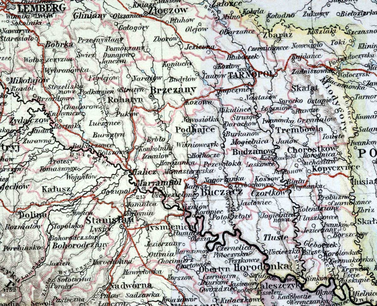
4. Centred on Podhajce,
this map
extends from Lemberg in the northwest to Okna in northern Bukovina in
the southeast (366k).
5. Here's an 1897 map of southeastern Europe
from the same
atlas: Lots of rich detail considering the vast expanse of territory.
It covers from Czernowitz in the north northeast to Constantinople in
the south east; and from Hungary in the northwest to the Adriatic in
the southwest. It's quite large and was hard to reduce and still keep
all the place names legible. A compromise on my part, not Ivor's (820k).
6. An excellent 2006 pictorial
streetmap
of downtown Czernowitz with the Ukranian street names shown in Latin
characters (English that is). This is the map that used to be on
the home page during the reunion.
7. This is the Czernowitz map enclosed with the "Illustrierter Führer durch
die Bukowina" from Hermann Mittelmann 1907/1908. Probably taken
from the reprint by Helmut Kusdat, 2002. I'ts a large, easy
to read, full colour 1907
street map of Czernowitz -- about 700k
8. Here's a map of historical interest: The orginal is a street
map from 1787,
but published in 1887. It was used for tax assesment purposes. It does
locate the 'Old Synagogue' (28). Peter Elbau translated the
Gothic script which is overlayed on the map. Another large file --
about 800k. (from the Gruss aus Czernowitz Live Journal)
9. 1935
Cernauti
city map showing bus and trolly lines withmajor places of interest
clearly indicated.
10. An excellent 300 dpi Czernowitz street map from Austrian
times
(E.Hauster)
11. An excellent 300 dpi Czernowitz street map from Romanian
times
(E.Hauster)
11a. Another Czernowitz
street map from Romanian times, somewhat wider prospect (Valsile
Craciunescu)
12. 1870 Czernowitz
Plan - more compressed. File size now 2.2MB but same physical
size as the
original posted at LiveJournal by Edward Tur
13. Excellent
high
quality reprint of 1878 map of Bukovina
& Galicia in Hebrew. By way of E.Hauster and
courtesy of Scholem & Friends
14. From Jim Wald, a 1789
pictorial map of
Bukovina (Franz Johann Joseph
von Reilly, Schauplatz der Fünf Theile der Welt.
Mit bestündiger
Rücksicht auf die besten Originalwerke in Drey Theilen... (Vienna,
1789)).
15. A very
fine French map of the Austrian
Empire
(1812) From Jim Wald.
16. From Leo Spitzer and Marianne Hirsch, an extraordinary high
resolution map of
the Czernowitz
Ghetto indicating the streets that were included in the ghetto in
its first configuration when it was created on October 11, 1941. It is
based on official Romanian information published in Cernăuți in the
Romanian language newspaper “Bucovina” on Saturday, October 11, 1941,
the day the ghetto was officially established.
17. A German July 1940
military map labeled 'Czernowitz' consists of four knitted together
maps {parts of Russian Poland and Romania} and was almost certainly
used by Nazi troops in the invasion of Russia and thus Czernowitz.
This version is re-processed for the web to a file size 5MB and
will take a while to load. The original (42MB) came via Vasile
Craciunescu from mapywig.org. Peter Elbau interpreted the map for the
notes above. The composite map shows 1 degree of longitude x 1/2 degree
of latitude and contains exceptional detail (about 2,450 sq miles is
presented).
18. By way of Rob Gartenberg, here are links to three excellent
maps held by the Austrian War Museum and presented by the Centre for
Urban History of Central Europe in Lviv:
http://www.lvivcenter.org/en/umd/map/?ci_mapid=53
- a map of Czernowitz from 1905.
http://www.lvivcenter.org/en/umd/map/?ci_mapid=50
- a Czernowitz map from 1888
http://www.lvivcenter.org/en/umd/map/?ci_mapid=47
- a Czernowit map from 1830
19. From Yosi (Jerry) Eshet an interesting early 1920's
Czernowitz street map: partly pictorial, with many streets showing both
German and Romanian names. Another Leon Konig gem, excellent resolution
and condition. See it here.
19a. From David Dubowy, who found the original paper copy of the map in
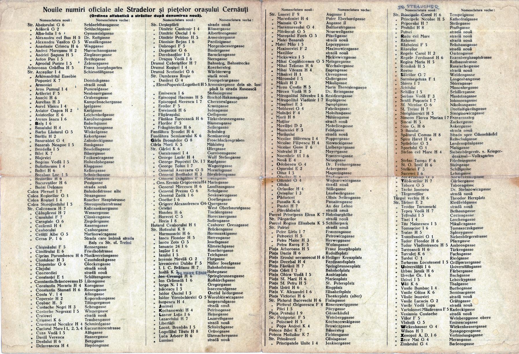
19 above, amongst his grandfather's papers: The Indexes for the
map sorted on: German
names Romanian
names
19b. For those more comfortable with the Pruth north of town we present
the 1920 map rotated
180 degrees
20. A selection of high resolution maps from the 3rd Military
Maping Survey of Austria-Hungary (1910). 177 maps in total
have
been made available on our website, The file sizes range in szie from
2-5MB. Each map
covers one degre of latitude by one degree of longitude. The
prime meridian for these maps is at Ferro in the Canary Islands and not
Greenwich. Fortunately, there is a master map of Central Europe showing
all the map sheets, and it is
'clickable' -- each map page has a major city indicated, so all
you have to do is mouse over to the sheet you're interested in and
click. Try it out -- these are superb maps!
The master map is here: INDEX
MAP
More detailed information for using the maps is Here.
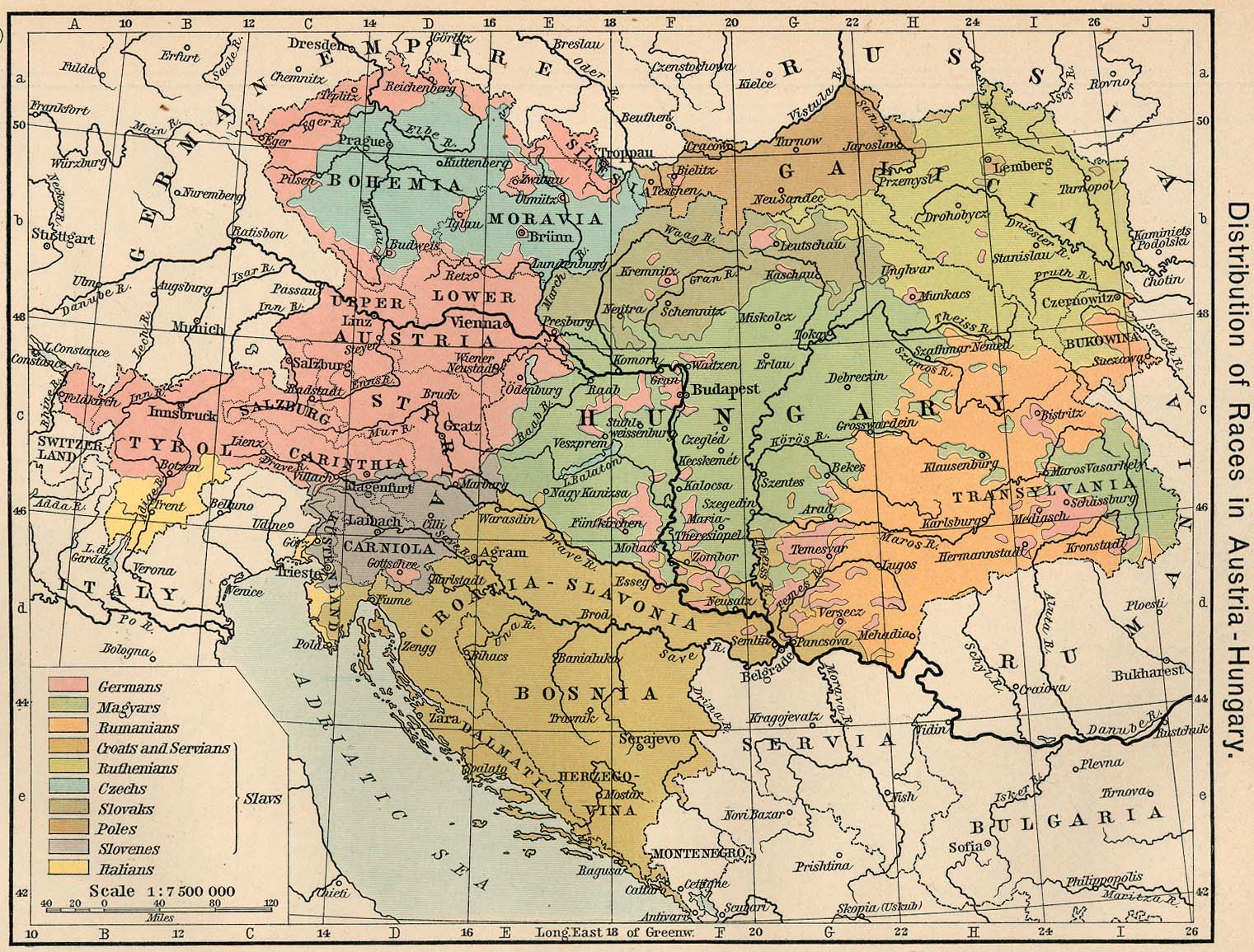
21. Three
good resolution maps of Europe: 1871 1910 1924 plus one 1911
map of Austria-Hungary -- very helpful in
visualizing the shifting borders and emergence of these European nation
states.
22. The next eight items (22a through 22h) are from Jim Wald - use your browser to zoom in on the maps.
22a. 1814 map of the Austro-Hungarian Empire
22b. 1830 map of the Austro-Hungarian Empire
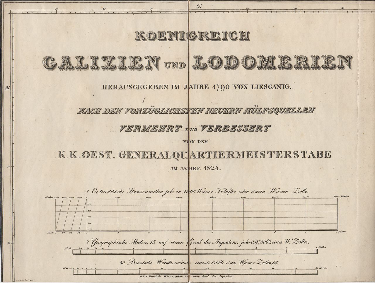
22c. 1824-1 military map papers - cover - Here
are some scans from the 33-piece military map of the Kingdom of Galicia
and Lodomeria, originally created by Joseph Liesganig (1719-99) in
1790, and revised and expanded by the Austrian Quartermaster's General
Staff in 1824.
22d. 1824-2 military map papers - statistics & map
22e. 1824-3 military map sample from the 33 piece collection showing Czernowitz
22f. 1824-4 another map from the collection
22g. 1813 map of Galicia
23h. Expanded southern section of the 22g above